

Reasons for Toxic Air
1. TRAP- Traffic Related Air Pollution
TRAP is a major source of air pollution in India, caused by slow moving traffic, which exacerbates pollution emissions due to heightened fuel consumption and diminished engine efficiency.
Researchers have found an 80 % increase in tailpipe emissions due to traffic congestion and that when vehicle speeds decline from 50 km/h to 20 km/h during congestion, emissions such as CO and CxHy can surge by approximately 50% due to partial burning of fuel.
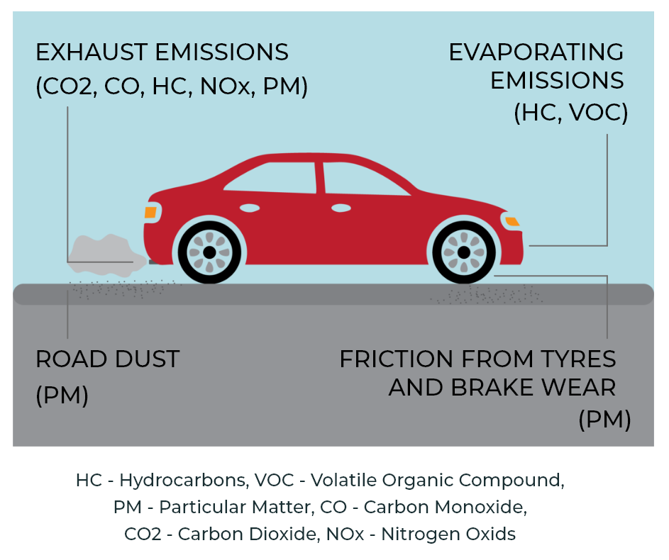
Also, constant braking and friction with the road surface results in creation of NEEs (Non Exhaust Emissions) releasing PM 2.5 and PM 10 into the atmosphere containing brake dust, fine rubber particles, heavy metals and VOCs.
2. BUILDING DOWNWASH - A Civil Engineering Challenge
Building Downwash is a wind-related phenomenon where wind striking tall buildings and/or structures, is deflected downwards, creating strong downdrafts at street level. The intensity of downwash is influenced by factors like building height, shape, orientation, and the surrounding urban environment.
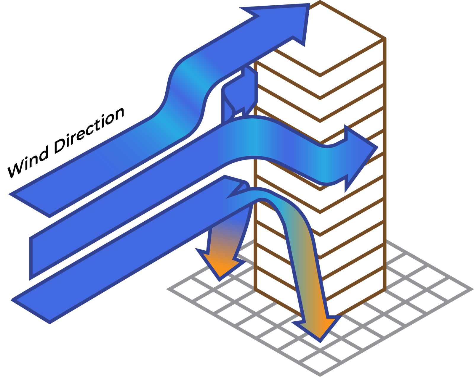
Buildings and similar structures in the path of air flow create a turbulent wake region, which is a low pressure area on the leeward (i.e., downwind) side of the building. A plume caught in the path of this flow is drawn into this area called the wake, temporarily trapping it in a recirculating cavity.
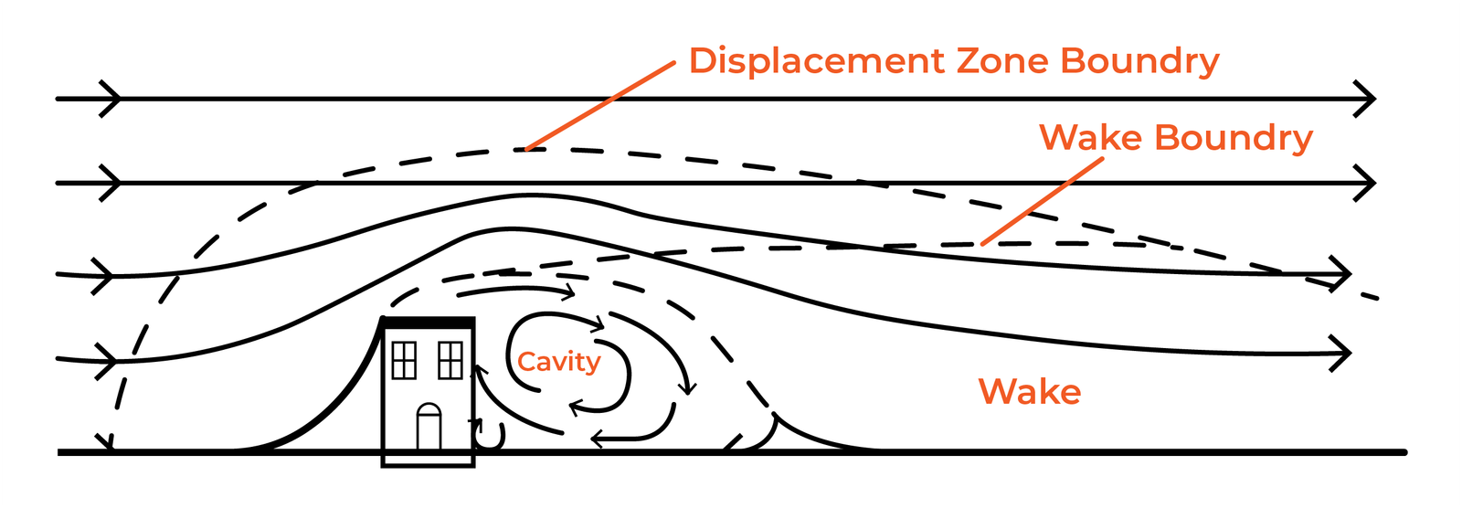
This downwash effect leads to higher ground-level pollutant concentrations near the building than if the building was not present.
Downwash effects can be classified as:
- Stack downwash, which is a possible drag of the effluent in the wake downwind of an emitting stack due to the presence of the stack itself.
- Building downwash, which can occur when an effluent is emitted near a building and is brought downward by the flow of air over and around the building.
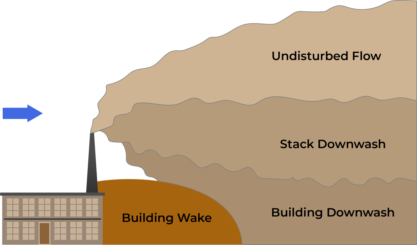
Stack and building downwash cause an increase of ground-level concentrations, because of two concomitant phenomena:
- (i) The drag of the effluent in the stack and/or building wake—since this wake extends below the stack outlet, this drag causes the plume to decrease in height;
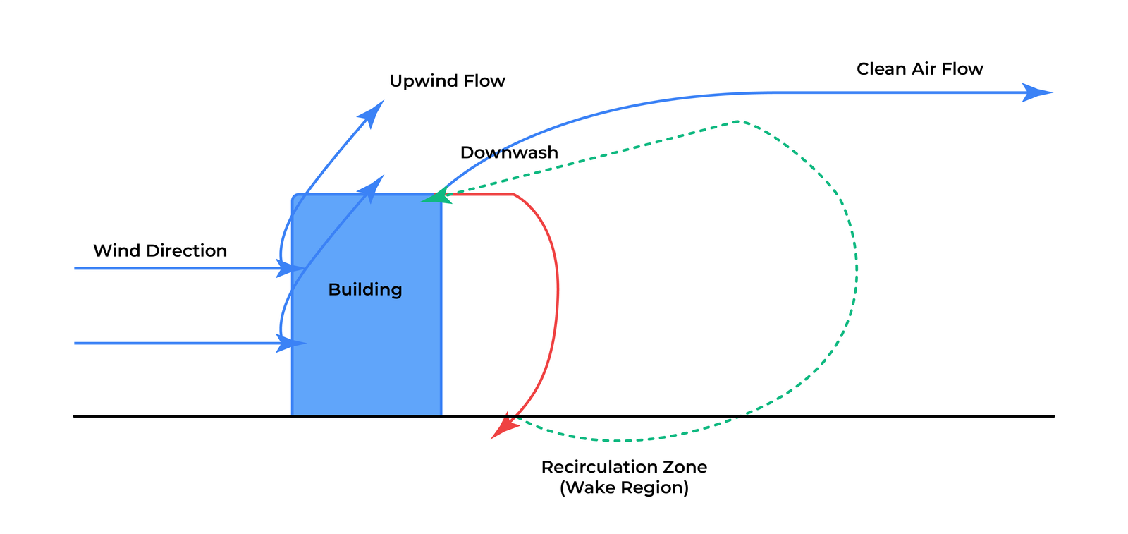
- (ii) The increase of entrainment with ambient air due to wake turbulence—causing a consequent decrease of buoyancy in case of buoyant emissions.
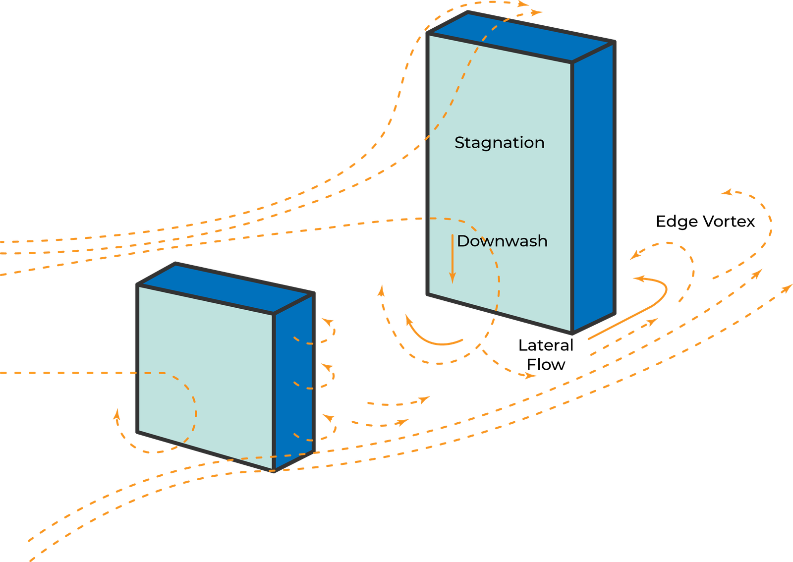
Building downwash effects are the cause of maximum concentrations in approximately 90% of dispersion modelling studies.
3. STREET CANYONS- Poor Urban Design
A 'Street Canyon' is defined as a confined urban space surrounded by buildings on both sides of a street, where natural air ventilation is limited, leading to the accumulation of pollutants from vehicle emissions and other sources, posing health risks to pedestrians and residents.
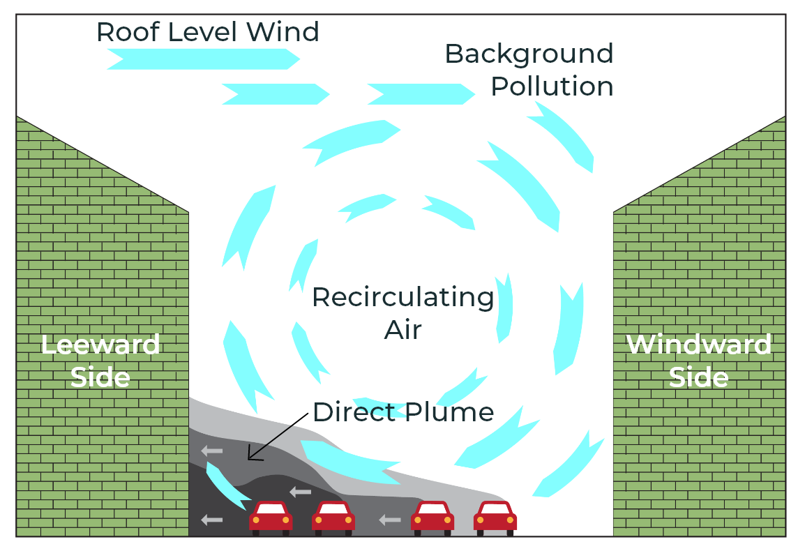
Street canyons vary in structure, including the aspect ratio (AR), asymmetry etc, which significantly influence wind field and pollutant dispersion within the street canyons.
Radiative geometry of canyon contributes to lowering the effective albedo of the urban environment, which means it absorbs more incoming solar radiation, mainly because of the multiple reflection of radiation between the canyon surfaces.
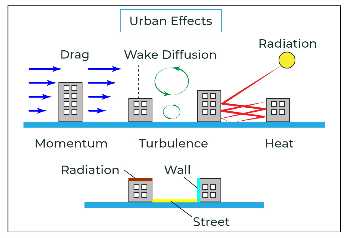
This same phenomenon is also responsible for poor signal reception in cell phones and TV signals in densely populated areas.
4. THE CANOPY EFFECT - When Trees Increase Pollution
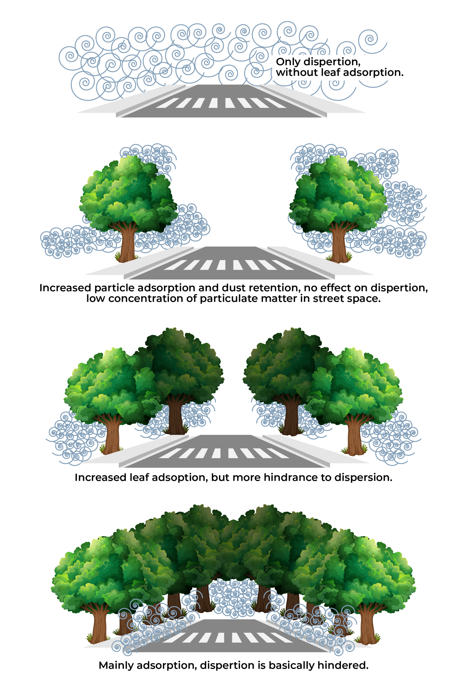
The canopy effect in urban areas refers to how trees and other vegetation influence air pollution levels by modifying wind patterns, temperature, and pollutant concentrations.
While vegetation can help remove pollutants like PM2.5 and ozone through processes like deposition (particles sticking to leaves) and stomatal uptake (gases entering leaves through small pores), it can also trap pollutants within street canyons, because of the geometric structure of urban canyons, with buildings and by hindering wind flow. Trees can also emit volatile organic compounds (VOCs), which can react with other pollutants like nitrogen oxides (NOx) to form ozone.
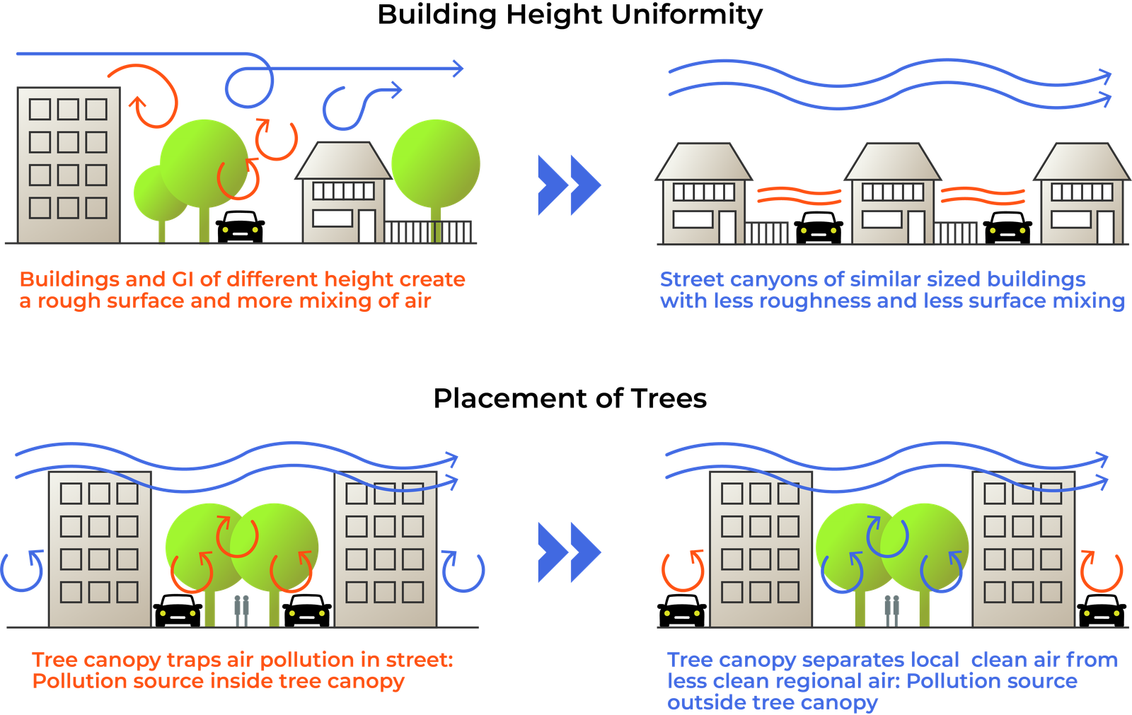
Tree crowns also generate airflow
resistance, which reduces turbulent kinetic energy, and change wind profiles, and cause local
reversal, thereby promoting particle aggregation or re-suspension. Evidence indicates that higher
pollutant concentrations are more likely to occur under denser tree canopies.
Overall, the canopy effect is complex and depends on factors
like canopy density, tree species, urban geometry, and meteorological conditions.
While urban greening can contribute to air quality improvement, it's not a simple fix and can sometimes
exacerbate pollution in certain areas.
5. URBAN HEAT ISLAND (UHI) - A self-perpetuating problem
The Urban Heat Island (UHI), is a phenomenon where near-surface air temperatures are higher than their non-urban surroundings, particularly at night.
Built urban sites have large areas of exposed surface per unit area of ground cover. Therefore, potentially more solar radiation can be collected on a built urban site than on flat open terrain. In urban areas, the lack of vegetation converts more incoming energy into sensible heat whereas, in rural areas, the energy is transformed into latent heat. The sensible heat is stored in the urban fabric and released slowly causing an urban heat island in the nighttime.
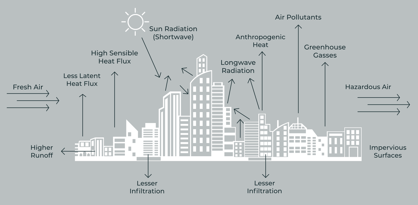
The primary factors contributing to this phenomenon are the properties of urban infrastructures, reduced sky visibility, decreased relative humidity and latent heat flux, increased sensible heat flux, diminished vegetation coverage, and limited open space in urban environments.
Rising pollution levels in urban areas may amplify the UHI effect because of the radiative impacts of various atmospheric pollutants that harm human health and contribute to smog formation and sometimes acid rain.
Dense urban areas with concrete structures and limited greenery absorb and retain heat, raising local temperatures and altering air circulation. This traps pollutants like PM, NOx, and ozone, while promoting secondary pollutant formation (e.g., ozone via VOC-NOx reactions).
6. THERMAL INVERSION - Why pollution is visible in winters
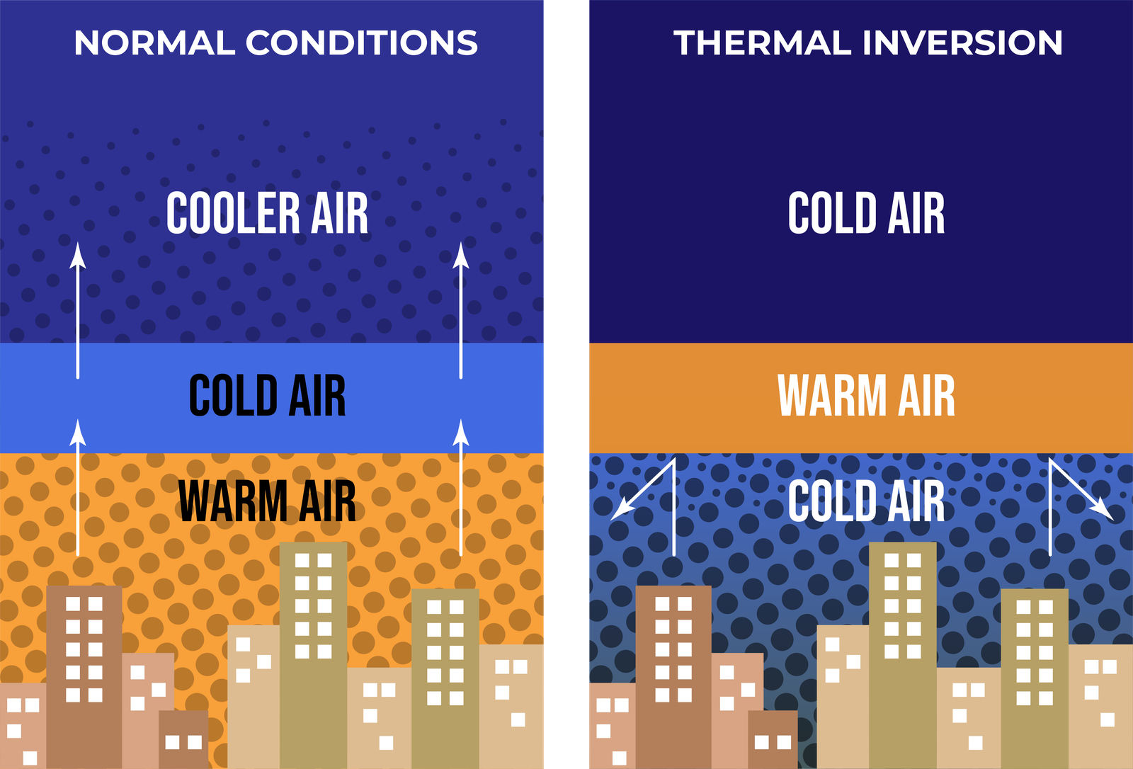
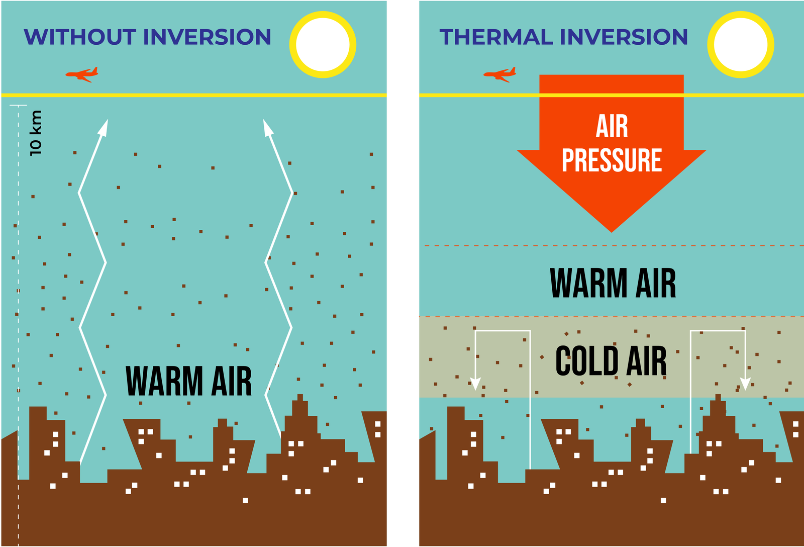
A thermal inversion is a meteorological phenomenon where a layer of warmer air sits above a layer of cooler air.
Typically, as you move higher into the
atmosphere, the air temperature decreases. In a thermal
inversion, this normal pattern is reversed, and
the temperature increases with height.
This can happen when the Earth's surface cools quickly
at
night, transferring that cold to the air near the ground.
The layer of warm air above acts like a lid, preventing
the
cooler, polluted air below from rising and dispersing.
As the weather gets cooler in winters, the inversion height (the layer beyond
which
pollutants cannot disperse into the upper atmosphere) comes down making larger concentrations of
pollutants in the air hang closer to the surface, and lead to worsening AQls.
In essence, thermal inversion in India acts as a catalyst for air pollution, exacerbating the effects of
other pollution sources and creating a dangerous environment for residents, particularly in winter.
7. PLANETARY POLLUTION - Poor Airshed Management
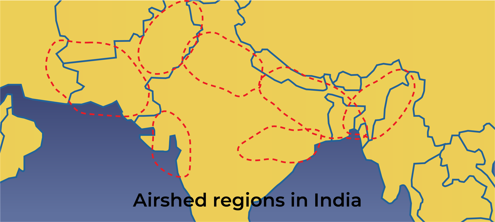
An airshed is a common geographic area where pollutants accumulate and impact air quality. It includes the entire area over which the pollutants disperse due to meteorological and geographical factors. India has 6 large airsheds.
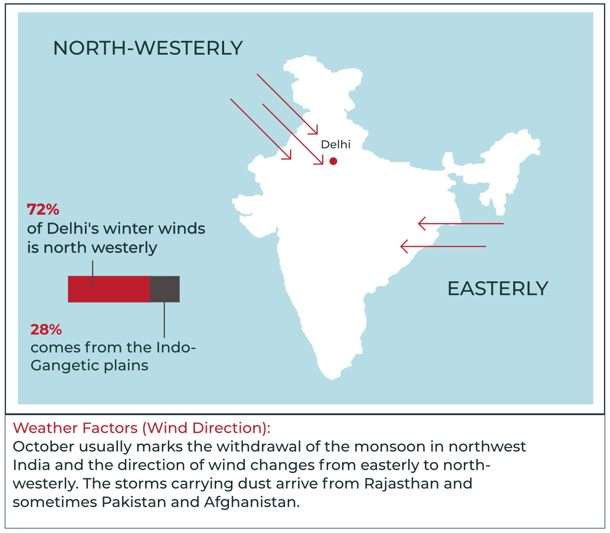
During the southwest monsoon, the prevalent direction of the wind is easterly. The winds travel from over the Bay of Bengal, carrying moisture and rainfall to this part of the country. The Easterlies carry pollutants, too, along with moisture and rainfall.
Once the monsoon withdraws, however, the predominant direction of the winds changes to north-westerly. These winds carry particulate matter (essentially smoke, dust and soot), and Ozone from other countries of Europe and Central Asia, into India.
So, for example, we see the Indian subcontinent receiving the pollution generated
in, Europe and the tropical rain band shifting as a
result, causing less rainfall in India. This contributed to one of the worst ever droughts in India
in the year 2000,
which affected over 110 million people in the country.
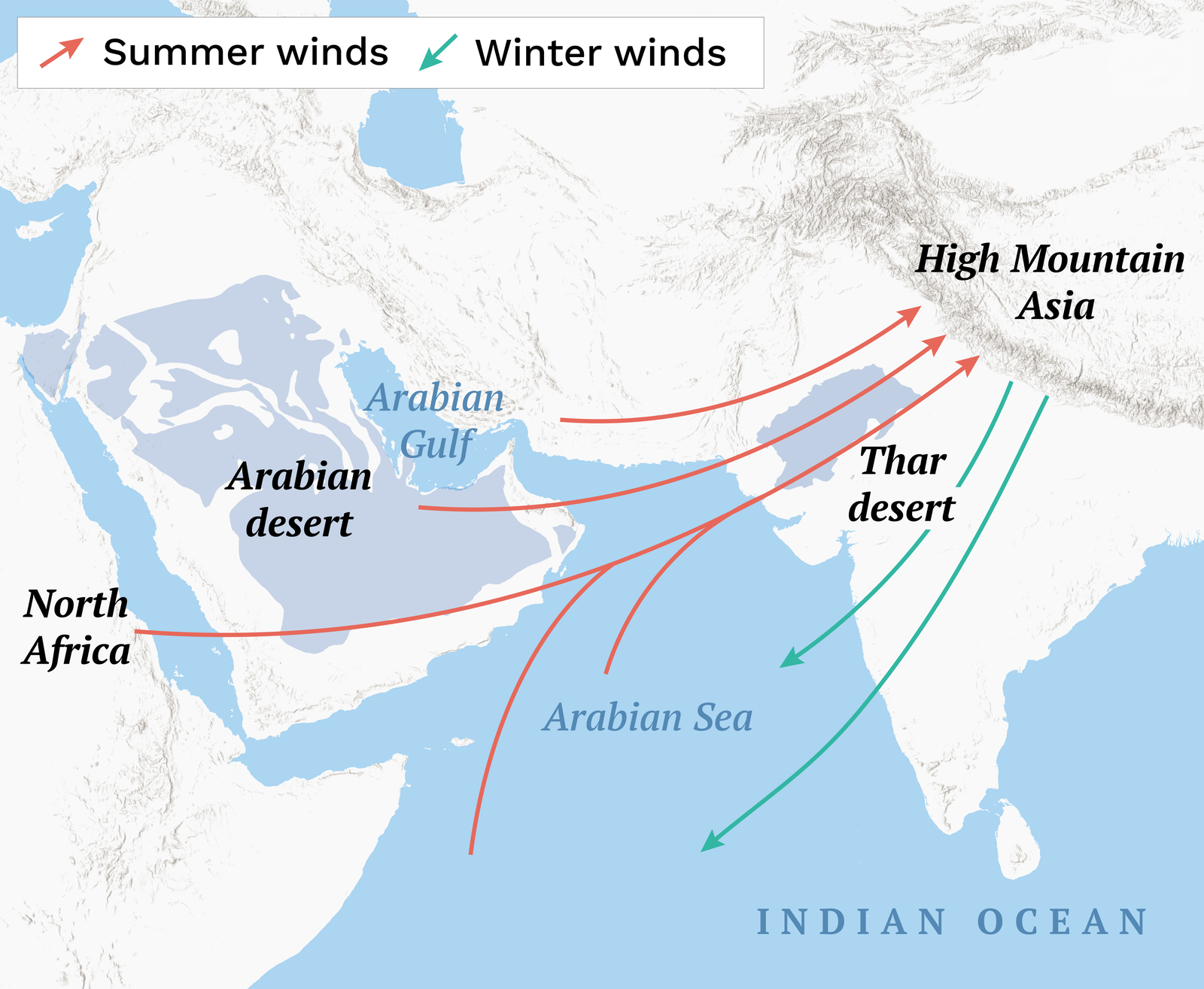
Or the dust from the Arabian Desert melting Himalayan
glaciers and contributing to regional climate
impacts.
8. TOPOGRAPHICAL CONSTRAINTS- Location, Temperature and Humidity
India's geography, particularly the Indo-Gangetic Plains and Himalayan foothills, traps pollutants due to low wind speeds and basin-like terrain, limiting dispersion of PM, SO2, and ozone. This affects northern India, where flat plains and Himalayan barriers create a "pollution bowl", exacerbating winter smog with primary and secondary pollutants as air pollution becomes trapped due to a combination of factors, including topography and weather patterns
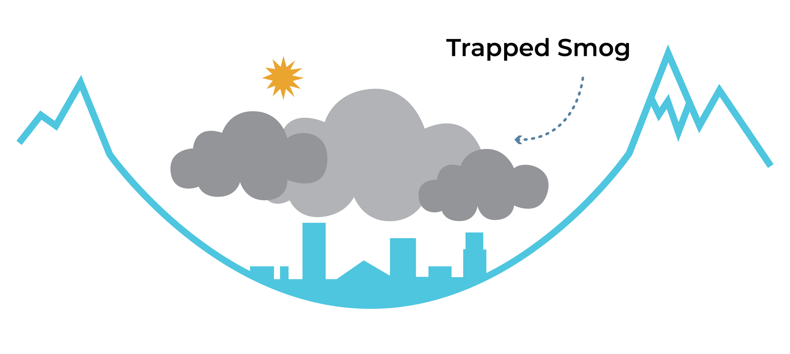
The pollution in the "bowl" is a result of various factors, including vehicle and
industrial emissions, dust from the Thar desert and Himalayas, road dust, and other sources.
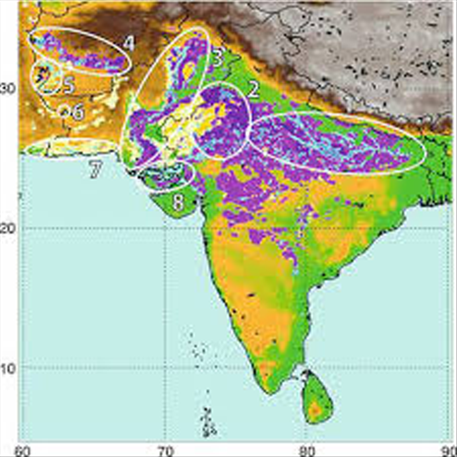
Unsustainable agriculture practices in the arid and semi-arid region of the country and rampant clearing
of forests broke the ceiling and created dust storms that damage property and crops. It is past time
India too recognizes its own Dust Bowl and initiates a large-scale
ecological restoration programme to
halt it. Else, we will see increasingly intense dust storms, and a choked Delhi would be a permanent
feature.
Also, India's humid climate (80 - 90% in coastal cities) and monsoon patterns increase aerosol formation
(e.g., secondary PM, sulphate aerosols) and bioaerosol proliferation (e.g., fungal spores, bacteria).
Humidity enhances pollutant deposition on surfaces,
re-aerosolizing them later and exacerbating
conditions
9. IMPROPER WASTE MANAGEMENT - Waste Burning and Open Landfills
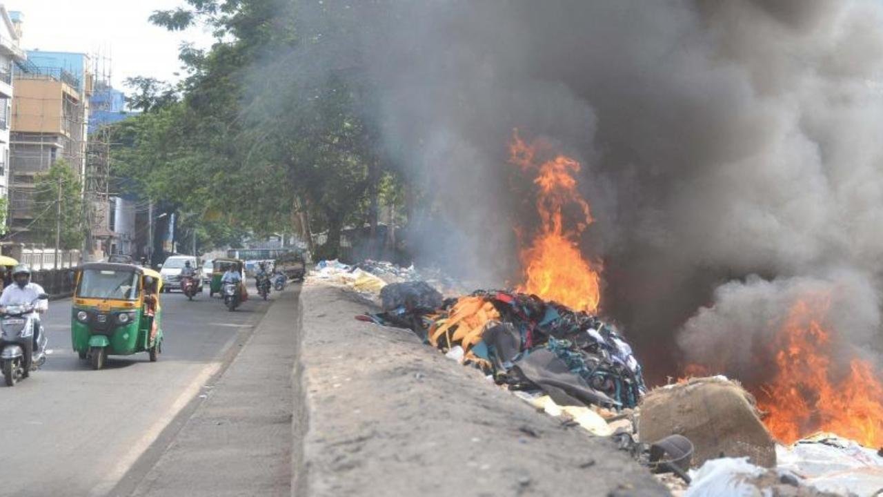
Improper disposal of hazardous waste substantially threatens air quality, leading to significant air
emissions that contain harmful collutants.
Waste burning emits a wide range of toxic compounds, including
dioxins, furans, heavy metals, CO2, PM and
volatile organic compounds (VOCS), into the air, which, upon inhalation, lead to respiratory problems,
cardiovascular diseases, neurological issues and even cancer upon
prolonged exposure.
Open improperly managed landfills present another significant source of hazardous waste air emissions. When hazardous waste is disposed of in open landfills without appropriate containment measures, it can generate LEACHATE and GAS EMISSIONS.
Hazardous waste materials may interact with moisture in the landfill, forming leachate, a toxic liquid that can percolate through the landfill layers and eventually seep into the surrounding soil and groundwater. Leachate can release hazardous chemicals into the air when it evaporates.
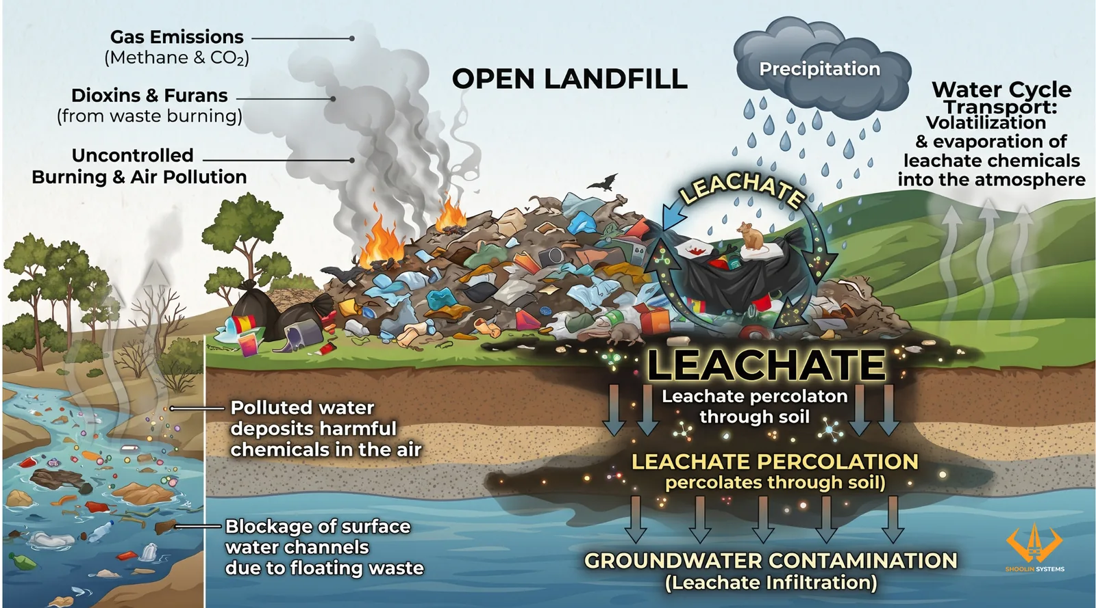
Anaerobic decomposition of hazardous waste in landfills can also generate landfill gas, mainly methane, carbon dioxide, and other volatile compounds. If not captured and treated properly, these gases escape into the atmosphere, contributing to greenhouse gas emissions and air pollution.
10. IMPORTED POLLUTION – Dirty Trade- ignorance, apathy and greed
Imported pollution refers to hazardous materials and fuels that enter India through global trade. Weak regulation, cost incentives, and limited domestic recycling capacity have turned India into a major destination for dangerous substances banned or restricted elsewhere. Some major such pollutants are as under.
ASBESTOS
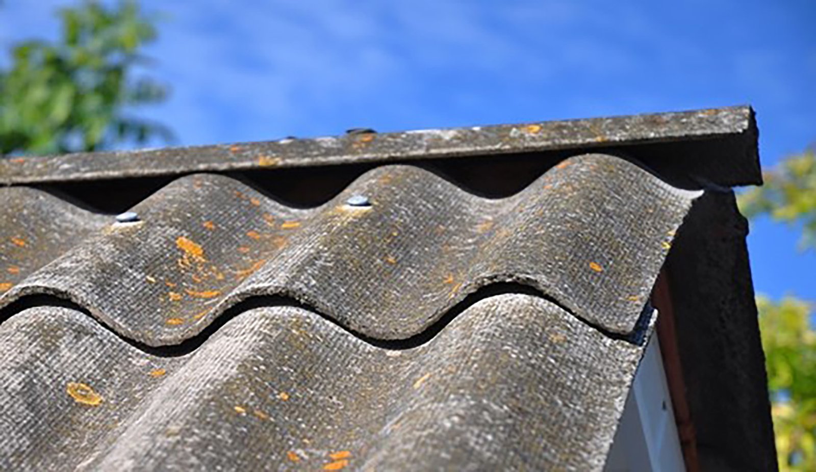
India is the worlds largest importer of ASBESTOS, a recognized carcinogen, in the world. Despite 72 other countries banning asbestos, India imports over 3 lakh tons annually of the material, though it has banned its own mining.
Asbestos is used widely in sectors like construction, automotive, and home goods, posing significant health risks such as lung cancer and mesothelioma to millions of workers and the general public.
Plastic and Textile Waste
India is a virtual dumping ground for foreign waste products, importing waste like plastic and textiles. The plastic is imported because imports are cheaper than recycling locally produced plastic waste. This imported waste is used to fulfill rising demand for plastic in India, which is the third largest consumer of plastics globally after the US and China, but is the largest plastic emitter in the world, openly burning about 58 lakh tons of plastics annually.
India is also among the top 5 importers of used clothing in the world. These clothes are recycled and re-dyed creating a separate pollution stream of its own, contaminating air, land and water in and around the processing areas, particularly the peri-urban clusters, with acidic fumes, VOCs, microplastics and PM.
https://www.indiatoday.in/india-today-insight/story/india-is-the-worlds-biggest-plastic-polluter-what-it-means-for-our-health-2745049-2025-06-23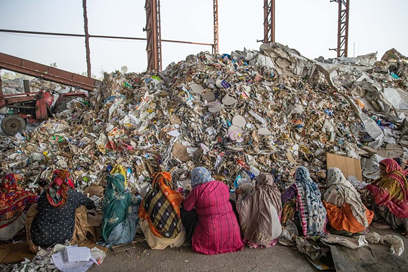
PETCOKE
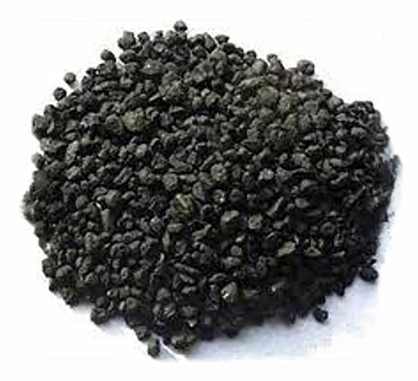
Petcoke is a byproduct of the oil-refining process and is extremely cheap. It has:
- More than double the sulfur content
- Higher heavy-metal content (vanadium, nickel)
- Higher carbon density
- Even dirtier than the dirtiest grades of coal
While many countries restrict or prohibit burning petcoke due to its toxicity, India imports 10 lakh tons every month for use in brick kilns, power plants, and heavy industries.
Its combustion emits SOz, NOx, mercury, toxic metals, and ultrafine PM pollution-all of which travel hundreds of kilometres across states.
USED TYRES and PYROLYSIS
India imports millions of waste tyres from the UK, US and Canada, often for processing in makeshift pyrolysis plants instead of formal recycling facilities. These plants operate in informal sectors, where tyres are subjected to around 500° C temperature in an oxygen-free environment to extract products like oil and carbon black.
Tyre pyrolysis, especially when done in unregulated or semi-regulated units, releases:
- PAHs (carcinogenic polycyclic aromatic hydrocarbons)
- Benzene and toluene
- Dioxins and furans
- Carbon black dust
- Thick black smoke rich in PM2.5 and PM1
These pollutants spread far beyond industrial zones, contributing to regional haze and chronic toxicity.
https://www.youtube.com/watch?v=G8Yr-Fdv8jo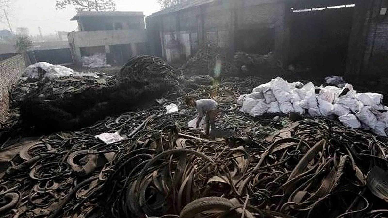
These imported pollutants significantly increase particulate matter and toxic emissions across Indian cities. For individuals, this means higher exposure at home, work, and in public spaces-making effective indoor air protection increasingly essential.
